Monday, October 10
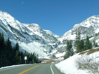
We left Durango this morning and drove along rt 550 to The Black Canyon of the Gunnison National Park. A portion of this highway is dubbed “the Million Dollar Highway”. Some say the name comes from the ‘million dollar view’ others say it is because there was 'ore in them thar hills.' We say the former ~ the views on this winding, switch backed road were tremendous ~ real ‘million dollar views’. It took us up over 10,000 feet of some of the most beautiful tree lined, snow covered mountains we have seen. The temperature dropped rapidly into the low 20’s but the sun was shining brightly.
Molas Pass at 10,899 ft
Along this winding 'million dollar highway'
First one way, then the other
Lean-to over the road for land slides and avalanches

We stopped along the way for a
picnic lunch at Pulpit Rock.
Molas Pass at 10,899 ft
Along this winding 'million dollar highway'
First one way, then the other
Lean-to over the road for land slides and avalanches

On our way back down we saw the town of Ouray called the ‘Switzerland of America.' We haven’t been to Switzerland but the town was nestled into the side of the mountain as we would expect to find in Switzerland.
 |
| you can barely see the river but you can hear it |
We arrived at the Black Canyon of the Gunnison around noon and began our tour. It was a small park but packed with amazing sights. Black Canyon, carved out by the Gunnison River, is one of the deepest, narrowest canyons in the United States unique in its narrow opening and almost vertical cliffs. It is so narrow that some of the canyon only receives sunlight at mid day when the sun is directly over head therefore making the canyon appear black which gives it its name. The mighty Gunnison River is still altering the canyon today. It continues to carve the canyon at a rate of one inch every hundred years.
We stopped along the way for a
picnic lunch at Pulpit Rock.
The Gunnison River drops an average of 34 feet per mile through the canyon making the fifth steepest mountain descent in North America. In comparison, the Colorado River through the Grand Canyon only drops 7.5 feet per mile.
The Painted Wall is the tallest vertical wall in the state of Colorado with a height of 2,250 ft. The lighter lines on the ‘painted wall’ are called pegmatite dikes which is actually magma that cut vertically through the rock almost 2 million years ago.
After viewing the canyon from several perspectives and hiking for several hours on the trails along the rim we headed to Alamosa, Colorado for the night.
 |
| along the road to Alamosa |


No comments:
Post a Comment